Web services
Snap to road API documentation, available via HTTP-JSON/XML service.
URL base service:
- JSON: https://lb.cercalia.com/services/json?key=<clave API*>
- XML: https://lb.cercalia.com/services/xmlgeo?key=<clave API*>
* API KEY. Same KEY used in maps API js
HTTP requests in GET or POST
Response in JSON / XML format
Get a route polyline from a GPS track (snap to roads) and speeding report
Request:
Example:
&cmd=geomtrack&mode=regular&TRACK=[2.825850,41.969279@0,45@@70@@@A],[2.822355,41.965995@0,45@@10@@@A],[2.828963,41.968589@0,45@@10@@@B],[2.828278,41.965013@0,45@@10@@@B]&SPEEDING=true&SPEEDTOLERANCE=10&SRS=EPSG:4326
Where:
|
TRACK |
List of ordered points, separated by commas, limited to a maximum of 5,000 points. Each point has the following format: [coord{@<compass>}{@@speed}{@@@atribute}] Where:
|
|
SRS |
Coordinate system of the list of points. Use EPSG: 4326 for geographic coordinates. |
|
WEIGHT |
Route type (default: distance) |
|
NET |
Country net used (optional) |
|
GEOMETRYSRS |
Coordinate system of the resulting polyline. By default use the same as the SRS parameter. Ex: EPSG: 4326 |
|
GEOMETRYTOLERANCE |
Indicates the geometry tolerance (simplification) in meters |
|
POINTS |
Obtain the original coordinates of the GPS track displaced on top of the returned route (optional) |
|
SPEEDING |
Boolean value. If true, it returns the separated route sections for which the speed is exceeded and those which are not. |
|
SPEEDTOLERANCE |
Tolerance in Km / h on the maximum speed of the section. Speeding will only be considered if the vehicle speed exceeds the speed of the section by more than SpeedTolerance km / h. By default 0. |
Low-level control parameters:
|
ONLYTRACK |
If true it returns a multipoint geometry with the points of the route. Default: false |
|
MAXDIRECTIONSEARCHDISTANCE |
Maximum deviation that can exist between a point on the track and a point on the network that respects the orientation of the point. Default: 10 If no point is found, we proceed to search for it regardless of orientation. |
|
MAXSEARCHDISTANCE |
Maximum deviation that can exist between a point on the track and a point on the net regardless of orientation. Default: 20 If no point is found on the network that meets the distance, the point is added in a straight line to the result. |
|
FACTOR |
Factor between the distance in route and the line between two points. If this factor is exceeded, the route is ignored and the straight line is preferred. Default: 2 |
RESPONSE:
<cercalia cmd="geomtrack" version="1">
	<track>
		<geometry speeding="true" speedinglevel="2" distance="123">
			<wkt>
			LINESTRING (-3.7102887167967693 40.42997776054614, -3.7091707575880277 40.42986535088826, -3.7089192293084743 40.429844756839465, -3.708748549404491 40.42983789215513, -3.7077514194391186 40.42973492180528, -3.707419042783995 40.42971432771623, -3.706754289473746 40.42965941011441, -3.706305131831686 40.42961822188338, -3.706161401386227 40.429590763048566)
			</wkt>
		</geometry>
		<geometry speeding="false" distance="123">
			<wkt>
			LINESTRING (-3.7058110584254202 40.42954271006045, -3.7054517323117726 40.42948092759633, -3.705379867089043 40.42947406287456, -3.704751046390159 40.429398550888514, -3.703717983813422 40.429220067672745, -3.7033047587827275 40.429137690642925, -3.7024064434986075 40.42898666582415, -3.7023615277344017 40.428972936278214, -3.701984235315071 40.42892488284522, -3.701409313533235 40.42880131671579, -3.7005109982491153 40.42861596709264, -3.6999360764672793 40.428485535567766, -3.6994150536024897 40.42838942796525, -3.698436860020802 40.428197754472336)
			</wkt>
		</geometry>
		<points>
			<point>
				<from x="-3.074694" y="43.352639"/>
				<to x="-3.0746008408859975" y="43.35254856142673"/>
			</point>
		</points>
	</track>
	<server>http://cercalia-tomcat-lbs-instance3:8080</server>
</cercalia>
Where:
geomtrack= route polyline in WKT format (linestring / multilinestring)speeding="true" -> in this road section the maximum speed has been exceeded, taking into account the tolerance indicated."false" -> in this road section the maximum speed has not been exceeded, taking into account the tolerance indicated.
speedinglevel= only reported if speeding = "true". Provides the speeding zone for this section, linked to the speed value indicated in the &speeding= parameter. For example, with a &speeding= value of 10 km/h and without speedtolerance, if a vehicle drived at 55 km/h in a section limited to 50 km/h, the speedinglevel value will be 1, while if it was circulating at 67 km/h, then will be 2.distance= provides the distance of every track, in meters. It helps for generating a statistic of sections, with a differenciation of speeding value.
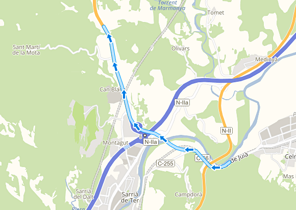
Polyline visualization:

